
Flood Study Planning Near Existing Culverts
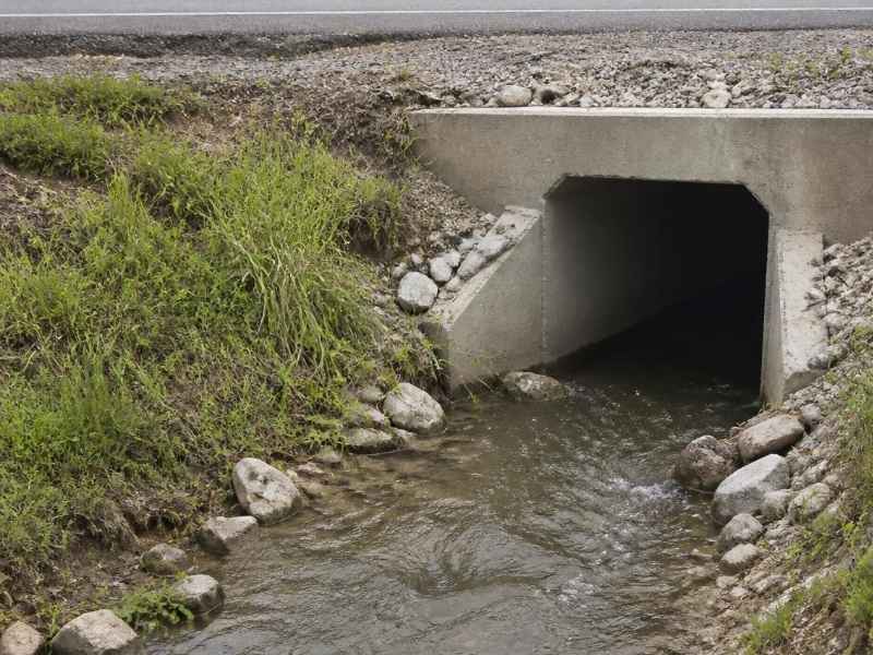
A small pipe under a road carries more risk than most people think. When a culvert is too small or clogged, water backs up and floods the land around it. A flood study looks at how water moves through that culvert during a storm. It shows whether the culvert can handle heavy rain or whether it puts nearby property at risk. This guide explains what a flood study near a culvert covers and how the results help you plan.
Existing Culvert Condition and Site Characteristics
A flood study starts with the culvert itself. A culvert is the pipe or box that carries a stream or ditch under a road or driveway. Engineers measure its size, shape, and material before any analysis begins.
Condition matters just as much as size. A pipe that is cracked, rusted, or half full of dirt cannot carry as much water as a clean one. Engineers check the inlet and outlet ends, the alignment, and any signs of past damage.
The land around the culvert tells part of the story too. Road height, ground slope, and nearby low spots all affect where water goes in a storm. A field visit and a topographic survey give the exact elevations the study needs to be accurate.
Culverts come in a few common forms. Some are round pipes, others are square or arch-shaped boxes, and a site may have more than one set side by side. At stream crossings, the culvert must also accommodate the flow path and conditions of the channel it carries beneath the road. Knowing the exact type and count helps engineers judge how much water the crossing can pass.
Watershed and Drainage Patterns Affecting Flow
Next, engineers look at where the water comes from. The watershed is the area of land that drains toward the culvert. A larger watershed sends more water, so its size is one of the first things measured.
Land cover shapes how fast that water arrives. Woods and fields soak up rain and slow it down. Pavement and rooftops shed water fast, which raises the peak flow reaching the culvert.
Upstream growth can change the numbers over time. New homes, roads, and parking lots add hard surfaces that push more runoff downstream. Engineers study the channel shape and past storms to judge how much water the culvert must handle and when that water will peak.
Hydraulic Capacity and Potential Flow Restrictions
Capacity is the heart of the study. Engineers figure out how much water the culvert can carry before it backs up. They compare that limit to the flow expected in different storms.
Several problems can choke a culvert. Backwater happens when water piles up behind an undersized pipe and floods the land upstream. Overtopping is when water rises over the road, which is both a flood risk and a safety hazard for drivers.
Debris is another common issue. Branches, trash, and sediment can block the inlet and cut capacity fast. Engineers also check flow speed, since water moving too fast can scour the channel and erode the banks near the outlet.
Finding these limits early pays off. A culvert that looks fine on a dry day may still fail in a real storm. The study spots that gap before flooding proves it the hard way.
Flood Study Modeling and Water-Surface Evaluation
Modeling is where the numbers come together. A flood study uses two types of models to picture a storm. The hydrologic model estimates how much water runs off the watershed, and the hydraulic model shows how that water moves through the culvert and channel.
These models run several storm sizes. Engineers often test common storms and rare, severe ones to see the full range of risk. Each run predicts peak flow, water-surface height, and how fast the water moves.
The results paint a clear picture of the flood hazard. They show how high water will rise and whether it spills onto the road or nearby land. Because rainfall data and methods can vary by county and project, engineers confirm the right standards before they build the model.
Using Flood Study Results for Improvement Decisions
The study is only useful if it guides action. Once the risks are clear, engineers weigh the options for fixing them. The right choice depends on the size of the problem and the budget.
A culvert that is too small may need to be replaced or enlarged. Adding a second pipe or a wider box can raise capacity without a full rebuild. Erosion protection, such as rock aprons or reshaped channels, helps where fast water is cutting into the banks.
The results also guide bigger decisions. They can shape roadway repairs, drainage upgrades, or the layout of a future development on the site. Sharing the study early with the county or city helps line up permits and avoid surprises later.
Sometimes the best step is to watch and wait. If the risk is low, an owner may choose regular cleaning and inspection instead of a rebuild. Either way, the study gives a clear record to support the choice and any future permit.
Frequently Asked Questions
What is a flood study near a culvert?
A flood study near a culvert looks at how storm water moves through that pipe or box. It checks whether the culvert is large enough to carry heavy rain without backing up. Engineers use field data and modeling to predict flood levels and flow speed. The study then shows what improvements, if any, the site needs.
When should I get a flood study for a property with a culvert?
Get a flood study early if you plan to build, buy, or develop near a culvert. Water problems are far cheaper to solve on paper than after construction starts. A study is also smart if the road or land near the culvert has flooded before. Timing and requirements can vary by county and project scope, so confirm what your project needs up front.
Can a flood study help lower my flood risk?
Yes, a flood study points to the exact fixes that reduce risk at a culvert. It may recommend a larger culvert, erosion control, or channel work to move water safely. These changes can protect the road, the property, and the land downstream. Acting on the study early is the best way to keep a small issue from becoming a costly flood.
